Because it is Sunday, and I didn't have anything else to do except write some more.....here's more of my ramblings!!
I currently have the privilege of waltzing around the prairie along the Marias River; the exact area explored by Meriwether Lewis and William Clark back in June 1805. Why am I referring to them as total badasses? Because where I am able to drive 2 miles off-road through the prairie (trailblazing, anyone?), so that I only have to hike a half mile in this territory, they did not. As a matter of fact, they hiked and canoed all over the Louisiana Purchase territory without the sweet advances in technology that includes motorized vehicles, gps's, and modern maps. And now, having been in the exact area they explored, I have a new found respect for them. Though I must add, I will continue to (1) think that Meriwether is a totally sissy sounding name, and (2) read "Lewis and Clark," think "Louis and Clark," and then giggle to myself and think "Superman!!!"
I currently have the privilege of waltzing around the prairie along the Marias River; the exact area explored by Meriwether Lewis and William Clark back in June 1805. Why am I referring to them as total badasses? Because where I am able to drive 2 miles off-road through the prairie (trailblazing, anyone?), so that I only have to hike a half mile in this territory, they did not. As a matter of fact, they hiked and canoed all over the Louisiana Purchase territory without the sweet advances in technology that includes motorized vehicles, gps's, and modern maps. And now, having been in the exact area they explored, I have a new found respect for them. Though I must add, I will continue to (1) think that Meriwether is a totally sissy sounding name, and (2) read "Lewis and Clark," think "Louis and Clark," and then giggle to myself and think "Superman!!!"
 |
| Map of the Lewis and Clark Expedition routes in Montana. See the blue loopy-loop? That is along the Marias River. (Lewisandclarkpictures.com) |
I feel that unless you actually see the Marias River (pronounced Ma-RYE-us) area in person, you may not truly understand what I will try to explain. It was originally named "Maria's River," but it seems that in Montana, possessive words tend to get annoying and subsequently altered. For example, the Bear Paws or Bear Paw Mountains, as locals alternatively call them, are technically named the "Bear's Paw Mountains." I have even seen a road sign that had the apostrophe and "s" crossed out. And according to my boss saying "Bear's Paw" sounds like you have marbles in your mouth, and that it is difficult to say, or something.....anywho, I digress. Maria's River was the original name. The specific area I am surveying is approximately 2 miles west of the sweet tiny town of Loma (Ma's Cafe is there and rumor has it that their food is fantastic...one day I will eat there). Loma is 67 miles south of Havre along Highway 87, and about 55 miles north of Great Falls. Along this entire distance, Havre and Great Falls are the only two places that qualify in my book as "cities," as everything else in between is a smaller than small town. So, we're in the middle of nowhere, go figure.
 |
A view of the Marias River and the Lower Marias River Road. Yes, that small strip of dirt is the road.
|
Anywho. The area along the Marias looks like a miniature canyon. Some may call it a valley (as it is a lower area with a river and such), but it looks like a super large river cut through the prairie, creating a canyon on the prairie. To the north and south of the river there are very steep slopes leading up to a bunch of hilltop plateaus. When I say steep, I mean I chant "I am a mountain goat, I am a mountain goat..." as I scale up the slopes. According to my garmin watch, climbing up one of the easier slopes was a quarter mile walk. All I knew was that my calves burned, and I really wanted to be a mountain goat. These slopes are then cut into by what the locals call "coulees." Never in my life have I heard this term before, but it is one that I have quickly adopted. These coulees, filled with large sagebrushes, Prickly Pear cacti, and tall prairie grasses, are essentially large gulches, or draws, or ravines. I firmly believe they are tick breeding grounds. I. Hate. Them. I firmly believe that even the deer hate these areas, as evidenced by the fact that game trails avoid the bottoms of coulees. Smart deer.
 |
| Lower Marias River area hilltops, looking west. |
In the 10 days we've spent around the Marias, we've had at least 3 days of work post rainfall. Let me tell you, wet Montana soil is horrible. Or, to use a creative cowboy phrase I've learned since being in Montana, it is "slimier than greasy bat shit." You cannot drive in it, since the soil appears to have no bottom, and you'll quickly bury your vehicle. Scientifically speaking, the clay soil comes from glacial till and something called Claggett Shale, which combines to form a clay mixture commonly called gumbo.* However, I don't need any scientific mumbo jumbo. I know for a fact that when the soil gets wet, even a tiny bit, it becomes slimy and sticky, and clings to your shoes as you walk, making your feet heavy. In addition to the gumbo soil, inevitably a few days after the rain stops and the temperature increases, the mosquitos hatch and come out to feast. And holy crap they are everywhere! And when rain, greasy mud, and mosquitos are not issues, snakes are. We have encountered 2 rattlesnakes, (one with 6 buttons, and a baby one without any rattles, though he frantically shook his tail there was no noise, this I did not like!), and five blue racers (which are not poisonous, thankfully). I'm going to do some quick math: 10 days, 7 snakes. So, in 100 days, 70 snakes. Flying flapjacks! I really hope that math doesn't pan out....
To summarize: steep slopes averaging a 1/4 mile tall, slimy clay soil, snakes, mosquitos, and ticks. Archaeology takes you to all the classy places!
 |
| In my opinion, prairie indicates flatness...so where the hell did a valley come from?! But, yes. Lewis and Clark, and now my co-worker and I are roughing it through this cra....I mean, lovely area. |
Now, Lewis and Clark arrived at the junction of the Missouri and Marias rivers on June 3, 1805. Four days later, Lewis was complaining about the rain, in addition to other stuff, in his journal. He wrote:
"the grownd remarkably slipry, insomuch that we were unable to walk on the sides of the bluffs where we had passed as we ascended the river...In passing along the face of one of these bluffs today I sliped at a narrow pass of about 30 yards in length and but for a quick and fortunate recovery by means of my espontoon I should have been precipitated into the river down a craggy pricipice of about ninety feet."*
Now, don't get all uppity about the spelling and grammar. Evidently, it is only relatively recently that English spelling was standardized. Before that, people just wrote as it sounded. Personally, I think that works better...avoids all those stupid words with letters that don't make sounds and whatnot. On a side-note...what is an espontoon?! I think I need one since it clearly saved his life!
Again, I digress. That specific journal entry (June 7, 1805) goes on to talk about how miserable this area was for the expeditionaries, with more slipping down hillsides, horribly steep ravines, and rain. Though we haven't actually had to deal with rain while working, the other stuff rings completely true. I've walked along the tippy top of what can only be called a hilltop finger with sheer drop-offs to the east and west, and is maybe a meter wide. If the soil had been wet, I probably would have ended up down the coulee.
In closing! If Mr. Meriwether "Badass" Lewis complained, I feel completely justified in continuing my internal dialog of complaints!
 |
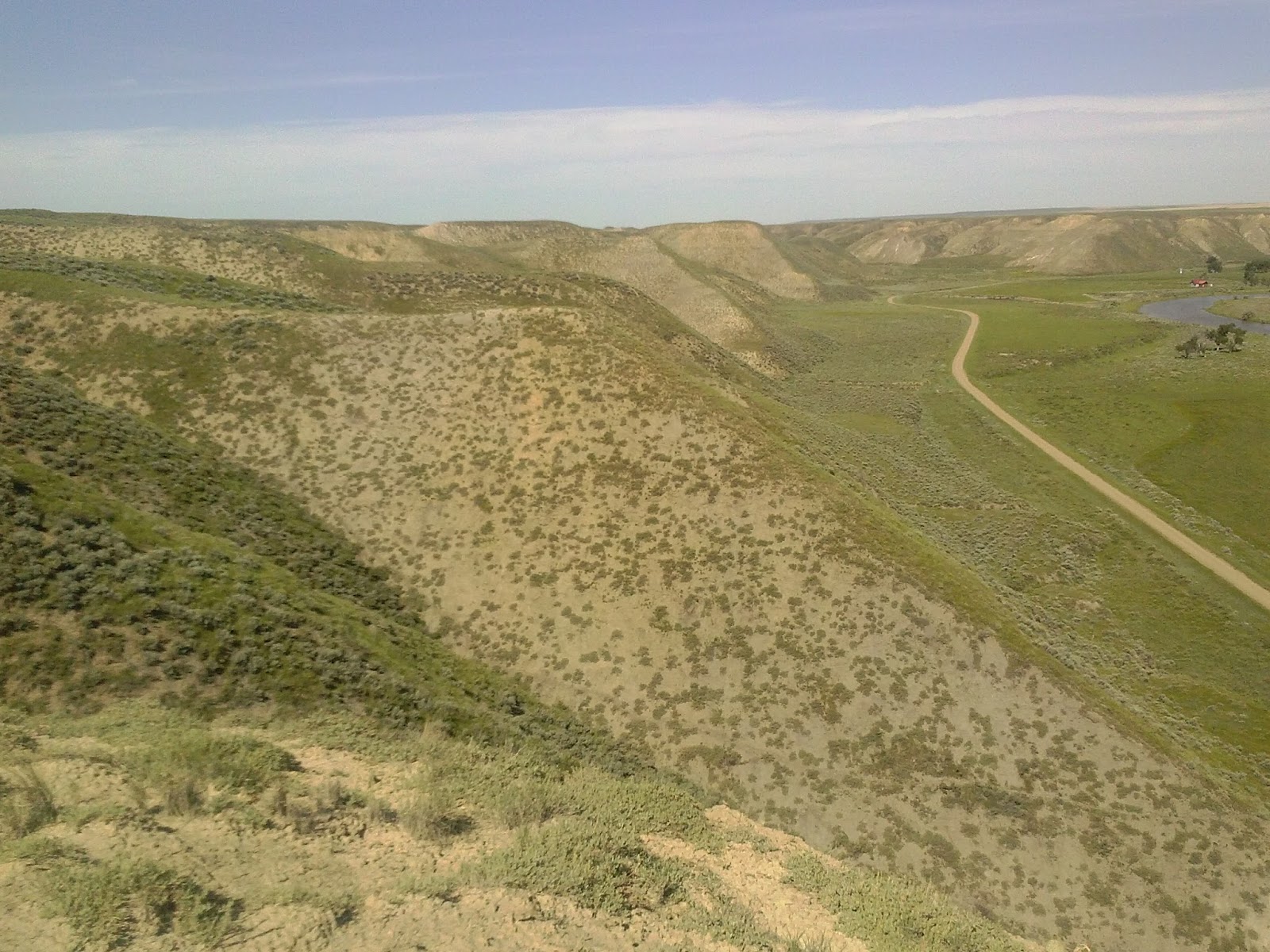
| I took this picture from a hilltop plateau just south of an area we have to survey. This is on the south side, and the valley from a previous picture is to the northwest, and then the Marias River is to the north, and there is another large coulee to the east. Driving here is not an option. Oh, archaeology, why do you take me to such places? |
*The Lewis and Clark Expedition Journals and maps can be found at the University of Nebraska-Lincoln's website, http://lewisandclarkjournals.unl.edu/index.html. I encourage everyone to read through them and discover the badassery all on your own.
No comments:
Post a Comment